Peter Pond newsletter :: May 2007 :: #30
Another milestone, a nice round number, 30. This newsletter comes soon after one sent on various subjects. This contains one slant, observations on Peter Pond by a learned Peter Pond Society member. He has as a lot to say. Stay with him.
JACKSON CHAPTER
John C. Jackson is a Peter Pond Society member in Olympia, Washington, who has written several books on western exploration. He sent me a chapter on Peter Pond that is a part of a book still seeking a publisher. First see his email to me and then the chapter, which appears in draft form. Following that are his footnotes. I find most interesting his dashing the notion that Peter Pond and Benjamin Franklin crossed paths, something I've been trying to check out, too. Glad to see someone else was wondering about it. It's also interesting that Peter Pond may have caught the attention of both Washington and Jefferson. His contributions to Canada are established, but maybe he did more for USA than many realize.
"Hi Bill, Glad to see the Peter Pond society paddles on. It has been some time since we have exchanged views. My last few years have been spent on biographies of Meriwether Lewis and John McClallen aka Captain Zackery Perch which are now seeking publishers. Those Lewis & Clark things brought up some related subjects, one of which might interest you as a closer look at the implications of Pond's time on the Saskatchewan and data he extracted from Indians he questioned. I've attached it in Word. Best, John C. Jackson
PETER POND'S MAP
"In late 1806 the decrepit old fur trader Peter Pond was sixty-six years old and broken down from the years he spent on the leading edge of the known part of North America. Too poor to spend his penny on a newspaper, he read the worn copy that a sympathetic neighbor passed on to him. The page reported the return of Captains Lewis and Clark from the crossing of the continent. Since the first of the year the old man had followed the widely circulated stories about the winter that the American explorers spent at the Mandan villages on the Miseeurea River. He knew those tribes from the years he spent trading with the Sioux who ranged between the Saint Peter's River (present Minnesota) and the Missouri.1
The return of the Corps of Discovery proved what Peter Pond had believed for the past quarter century, that the Missouri and the river of the west flowed from a central fountain. That was not quite a northwest passage but what those fellows did should take the shine off his former clerk's big trip to Bella Coola. Alex Mackenzie had been an ungrateful apprentice who stole Peter's vision of continental geography and greedily claimed the King's honors for proving it. Pond had been unable to even interest his own countrymen.
After gaining half of the continent during the revolution, there was a lot that Americans didn't understand about their geography. The treaty of peace that set the bounds of the new nation depended on several versions of a twenty year old map drawn by John Mitchell. However, acceptance of the treaty required congressional approval. The lack of an up-to date map should have generated geographical sensitivity among the delegates meeting in New York on 11 January 1785.
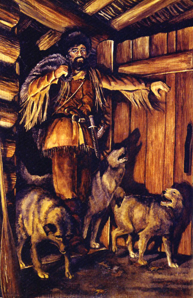
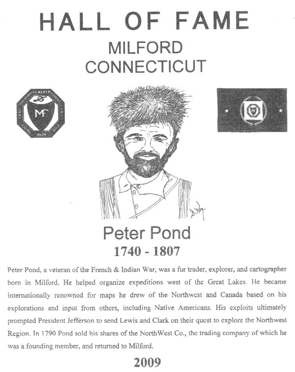
Sometime during February a visitor from the north, the far north, approached that body with a new map of the interior continent. Peter Pond was a native of Connecticut who spent several years conducting a family business that extended from the Carribean to the headwaters of the Mississippi River. With a reputation as rough traders the Ponds operated from Detroit. One of them had been killed just south of Michilimackinac by his drunken customers. That hadn't discouraged Peter from entering the western trade in partnership with a New York supplier named Felix Graham. When they renewed their association in 1773 Pond also fell in with the Montreal suppliers Isaac Todd and James McGill. Pond shifted his activities north and spent the winter 1775/76 at Lake Dauphin. The American rebel's invasion of Quebec momentarily checked the fur trade of the greater northwest but Pond moved up the Saskatchewan River for outfits 1776/77 and 1777/78. Next spring the traders on the Saskatchewan combined their residual outfits which Pond took farther north to Lake Athabaska.
During the two years he operated from a location about halfway up the Saskatchewan River Pond found opportunities to interrogate visiting northern plainsmen about the geography beyond the seemingly endless plains to the south. From what they related he began to imagine an overland connection to the Pacific Ocean.
At the end of the American revolution, the treaty of peace created a large problem for British Indian traders. The new international border threatened to cut off their access from the north shore of Lake Superior. In a compromise that is still preserved on the maps of today, the boundary separating the fledgling United States and British possessions followed the convoluted route through lakes and river that fur trade canoes used going inland.
In the fall 1784 Pond came out of the north to the Grand Portage on the north shore of Lake Superior and continued on to Montreal. Reorganization of the trade was underway and he was dissatisfied with his share of the combine meant to monopolize the trade. While visiting his family in Milford, Connecticut Pond put the finishing touches on the first version of his map of the northern continent. That remarkable chart was based on ten years personal experience on the rivers and lakes as well as a good deal of geographical information that he had collected from widely traveled tribesmen, like those he interviewed on the Saskatchewan.
Most historical consideration of Pond's contributions to geography has focused on his vision of the mythic northwest passage. But the 1784/85 map also looked west. From his Indian informants on the middle Saskatchewan, Pond had gathered enticing speculation about what lay at the head of the Missouri River which came close to the long chain of stoney mountains. Just across that barrier Pond drew in a westward flowing river and gave it the Cree language derivative name Naberkistagon. He used that name despite the fact that he had recently read the account of another former trader on the upper Mississippi River. Three years previously Jonathan Carver had published the name Ouragon.2
At a time when the fur traders of the great north were concerned about the sanctity of the voyageur mainline, Pond's attitude was soured by the travels of Jonathan Carver. During the war Carver saw an opportunity to exploit interest in the western parts of North America. In his version of early British activities on the upper Mississippi River, Carver or his London ghost writer enlarged upon the truth by recounting adventures that Pond couldn't swallow.3 Pond had a much better story about his own experiences. During the time that he spent trading up the St. Peter's River Pond had opportunities to interrogate his customers. Some of them were Nadouessioux or "little snakes" as their enemies had named them, Dakota, Nakota and Lakota as they saw themselves. Those former woodland peoples had spread westward and became plains ranging horsemen. From their accustomed camps the Yankton Nakota traveled four hundred miles to the east or west. Lakota, who eventually crossed the Missouri River, surely picked up suggestions about where that muddy river headed.
After abandoning the Sioux trade and transferring his activities north in 1775, Pond spent a couple of winters on the Saskatchewan River which gave him the opportunity to question the tribes of the northern plains. His trade would have been with Assiniboine who were distantly related to the Sioux he had known, and Cree who were trying to maintain their role as middlemen between the traders and more distant plains ranging tribes. Those Gens du Large were Atsinaa, Siksika, Kainah and most distant Piikani, who were later lumped together as Blackfeet. They traveled widely as the maps they later provided to other traders would prove. The information he had extracted from his widely ranging Indian informants included the landmark "3 sugarloaf Mounts"just north of the Missouri River and somewhere across the chain of mountains a "Salt Lake."4 Perhaps they convinced Pond about the proximity of the headwaters of the Missouri River to a steam flowing west to the great salt water. Although Pond's western geography was hearsay, it was not that far off. Drawn on Pond's map, the lines that traced the Missouri to the chain of Stoney mountains and the western river just beyond that his informants called the Naberkistagon were compelling suggestions of the overland link that he imagined.
After helping extend the trade north into the Athabaska country Pond's temper led to unfortunate encounters with fellow traders. At a time when the business was changing from individual enterprise to tighter corporate organization, Pond's style of competition was embarrassing. There was a distinct possibility that the rising moguls of the northwest trade would find a way to freeze him out. With that threat handing over him, Pond looked to the American congress for better appreciation of his accomplishments.
As a young man Peter Pond had fought for the British against the French. That was enough military experience for him and during the revolution he staid apart in the distant northwest. He was also a nutmegger by birth and should have had a connection through the Connecticut delegation to the Continental Congress. But the records of that body that met in New York do not mention his map. Nor is there any presentation of it in the congressional journals. Not even in the gossipy letters of its members. It appears that the Connecticut delegates made no presentation on Pond's behalf.
Despite the commonly accepted belief that congress considered the presentation and rejected it, the only proof of Pond's visit is a copy of his map that was traced by the French consul for the states of New York, New Jersey and Connecticut. The copyist Hector St. John de Crevecoeur had already published his Letters of an American Farmer which earned him connections to the intellectual community in France. He could not allow a very interesting contribution of geography to escape the attention of the enlightened community of Paris.
Crevecoeur annotated the map in English but transferred Pond's fulsome notes to a separate list written in French, dating the certification 1 March 1785. By then Pond must have been fidgeting to get back to Montreal and learn whether he had been included as a partner in the newly re-organized North West Company. That Pond had been in the states spreading confidential information about their inland operations must have put a bit of negative pressure on that decision.
Crevecoeur made his copy for the enlightened Duc de la Rochefoucauld-Liancourt, a scientific-agriculturalist and proponent of democratic reforms. The enlightened nobleman had been an intimate of Benjamin Franklin and now was of Thomas Jefferson. Surely scientific curiosity brought them to study Pond's geographical speculations.5 During the interesting autumn 1785 two French ships sailed on an exploration of the Pacific under the command of Captain Jean Francois de Laperouse. Conceivably those navigators might be interested in finding the outlet of the Riviere Naberkistagon.
The map must have arrived about the time that Thomas Jefferson, who had replaced Franklin and United States delegate to France, met John Ledyard. Ledyard was another Connecticut native who had previously sailed with British Captain James Cook, and wrote a book about it. But ships only cruised the perimeter of unknown continents. Jefferson encouraged Ledyard's scheme for a overland crossing of North America by approaching it through Russia. While Ledyard, all alone, was working across Siberia, Jefferson was off on an exploration of his own…a tour of southern France.
It is assumed that the Pond map made little impression on Congress. Since 1781 that body had a proven cartographer on board. Thomas Hutchins was a native of New Jersey who entered the British army and between 1764 and 1768 traveled and mapped on the Ohio and Mississippi as far south as New Orleans. During the revolution, Hutchins was still an engineer in the British army, until his correspondence with an old associate Samuel Wharton became so suspicious that it ended his military career.
In May 1781 Hutchins had taken the oath of loyalty to the United States which allowed him to accept the post of Geographer of the United States. Three years later he presented his "Narrative and Topographical Description of Louisiana and West Florida to the respected American Philosophical Society. On 20 May 1785 when a federal land survey system was enacted, Hutchins was just the person to initiate the public lands survey system. About the time that Pond was back in Montreal renewing his fur trade connections, Hutchins was beginning the survey of the first seven ranges north of the Ohio River.
Hutchins former association with the defunct trading firm of Baynton, Wharton & Morgan resurfaced in 1788 when George Morgan made an arrangement with the Spanish charge d' affairs. For the last three years Diego de Gardoqui y Arriquivar had been trying to exploit the selfish concerns of New England for a commercial treaty into the closing the Mississippi River to western exporters. That failing, Gardoqui was willing to plant a colony of Americans on the west side of the Mississippi River as a barrier against United States expansion. Morgan began recruiting settlers.
Although Hutchins set United States geography on solid track, he was flexible in his allegiances. By November 1788 Hutchins contacted Gardoqui with a request to be appointed "geographer to his Spanish Majesty." As an inducement he offered to "have plans made of all the rivers communicating with the Mississippi together with a description of the country and its produce..." That included "An Estimate for Exploring the Country Westward of the Sources of the River Mississippi towards the Pacific Ocean or South Sea." That project would require two years to complete and would cost approximately $28,000.
Hutchins was unfortunate to die of pneumonia at Pittsburgh on 28 April 1789. That spared him the disappointment when his old associate George Morgan visited New Orleans next month and came away feeling poorly received by Governor Miro. The colonial entrepreneur was back in Philadelphia on 28 July but took almost a month before he got together again with Gardoqui. Almost immediately Morgan abandoned the New Madrid project, and the settlers he led there. Moving on to other interests involved the administration of Hutchin's estate, including his papers and letters which eventually ended up in the collection of the Historical Society of Pennsylvania.
On 30 April 1789, the first president of the newly constituted nation, George Washington, was inaugurated at New York. Despite previous activities that were not entirely in the interest of the new nation, Morgan was still corresponding with the President about Indian matters in September. In October the charming but bothersome Gardoqui went home and Thomas Jefferson returned from Paris. The later read upon landing that the President had appointed him Secretary of State. Although Jefferson accepted the post in mid-February 1790 he did not begin his service until March. It appears that the enlightened amateur had no hand in the conception and authorization of a secret plan for an exploration of the Missouri River.6
What the Washington administration conceived in secrecy was a plan to follow that stream to its source and discover its connection to the head of the North River (the Rio Grande). But that represented an unauthorized circuit of the Spanish interior provinces, perhaps interesting scientifically, but politically risky. Spanish closures of the lower Mississippi were better resolved by diplomacy than an overt trespass with military implications. A threat, real or perceived, to the New Mexican silver mines could bring on a war.
Unthinkable! Unless....unless the father of the nation had a continental vision derived from the lines on Pond's neglected map. And before it was known that a coastal trader from Boston ran into the mouth of a river that he named for his ship...the Columbia. At that dramatic moment in the history of the continent, the nearly illiterate former trader Peter Pond was out of the skin game for good and struggling to compile a manuscript of his early adventures on the upper Mississippi.
That misspelled document never found publication. It is unlikely that the incurious Father Washington would have bothered to read it. But something in late 1789 brought the president's attention to the west. Was there a link between the copy of Pond's map and the order to send a secret expedition to the Missouri River?
On 20 December 1789 Secretary of War Henry Knox wrote a secret order to Brigadier General Josiah Harmar ordering him to "Devise some practicable plan for exploring the branch of the Mississippi called the Missouri, up to its source and all its southern branches, and tracing particularly the distances between the said branches and any of the navigable streams that run into the Great North River which empties itself into the gulf of Mexico. In order that you may better comprehend my Idea I send you a map of the said river, and its conjectural relation to the Missouri."7 The map to be used was not identified.
Something of a postscript developed thirteen years later. In July 1803 President Thomas Jefferson was trying to renew a contact with a former Spanish officer who had previously given him geographical information. Jefferson asked his friend asked Caspar Wister, the president of the American Philosophical Society, about the Spanish officer's suspicious claims of western discovery. Although they had copies of Alexander Mackenzie's book by then, Wister offered, "I shall write this day to Mr. Peter Pond (who is mentioned by Mr. Mackenzie) on the Subject [proximity of the Saskatchewan to the upper Missouri], he lives in Connecticut & I believe will give any information in his power, without any particular explanation respecting the reason for asking it."8
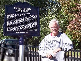
That is neither a proof or disproof of the influence that Peter Pond or his map had upon the plan that was already taking shape in Jefferson's mind. But it must have stirred memories for the neglected visionary, that were proved three years later when Pond read of the success of those American officers. Pond died in Milford the next year and the location of his grave, like the man and the map, has over the years been lost."
John C. Jackson, Olympia WA
"Bill, here are the notes. In the process of doing the Meriwether Lewis biography, I could see that the bicentennial was missing a lot of stuff that needed to be reconsidered. I finally ended up with enough little essays like this to make a book but too late to get in on the history gold rush. Use it, if you want. John c."
1. "The Narrative of Peter Pond," in Charles M. Gates, ed., Five Fur Traders of the Northwest (1933: Reprinted St. Paul; Minnesota Historical Society, 1965).
2.Robert Rogers initially used the name which was later publicized in Jonathan Carver, Travels Through the Interior Parts of North-America in the Years 1766, 1767 and 1768 (London: 1781; Ross & Haines, 1956).
3.Narrative of Peter Pond in Charles M. Gates, ed. Five Fur Traders of the Northwest (St.Paul: Minnesota Historical Society, 1965),38-39
4.Narrative of Peter Pond in Charles M. Gates, ed. Five Fur Traders of the Northwest (St.Paul: Minnesota Historical Society, 1965),38-39
5.Lake Pakowki and the Sweetgrass Hills most likely although there is a temptation to think of the Great Salt Lake and Trois Tetons. By 1785 Hudson's Bay Company travelers with the Piikani Blackfeet were already wintering there.
5.The story that Pond's observations influenced Franklin in the boundary decision is a invention. Franklin was in France for seven years and had no prior contact with the explorer.
6.The thrust of the exploration of North America follows the line begun by Pond, passed like a runner's baton to the widely admired Alexander Mackenzie. But his Voyages from Montreal was not published until 1801 which gave the Crevecoeur copy of Pond's map sixteen years to simmer in the minds of those who saw a continental destiny.
7.Donald Jackson, ed., Letters of the Lewis and Clark Expedition, 661. The Crevecoeur copy of Pond's map described the upper Missouri but showed the Nabarkistagon River flowing into the South Sea not the Pacific.
8.Caspar Winster to Jefferson, 13 July 1803 in Donald Jackson, ed., Letters of the Lewis and Clark Expedition with Related Documents,1783-1854 two vols, (Urbana: University of Illinois Press, 1978), 1:108.
JACKSON SUMS UP LEWIS & CLARK BICENTENNIAL
This pretty much restates what I have observed of the Lewis and Clark Bicentennial. I also thought it would get more hype than it received.
"Bill, you guys in the east were spared the excess expectations of the four year Lewis & Clark bicentennial, but it was seen as a renewal of interest in western history. Millions of sightseers were expected and new interpretive centers popped up at every campsite. Everybody was trying to get on the band wagon but few were willing to go beyond the journals and question what really happened. Lots of derivative books were published and the market saturated. But few pushed the envelope and when the celebration finally ended with a whimper instead of a bang, the expectations deflated. I published a few articles and wrote others like the Pond yarn as by-products of a biography I had been working on for years about the first officer to appear in the west after the expedition. I put that aside to help an associate complete a biography of Meriwether Lewis and what he did after the expedition, and both of those studies are presently seeking publishers. But anything to do with the expedition is pretty much dead in the water for now. The Pond map story is interesting because he obviously drew accurate geographical information about county he had not seen from the northern plains tribes he traded with when he was on the Saskatchewan, including what they knew about the headwaters of the Columbia River. But after the first map, that seemed to drop out of sight. I'm rambling this morning but I felt that Pond was an overlooked contributor to the L&C exploration while Alex Mackenzie is vastly overrated. John c."
Au revoir,
Bill
website design by Daniel Ortoleva